

Mining Landslide Mitigation: Recognizing the Risk of Surface Subsidence
In mountainous coal-mining areas, cracks in roads and slopes sometimes appear not after heavy rainfall, but months after an underground mine tunnel collapses and the overlying ground gradually subsides. Such cracking patterns can go undetected by conventional landslide monitoring, which generally focuses on rainfall, slope inclination, and surface conditions.
However, mine landslide mitigation cannot rely solely on natural factors. Underground mining activities leave changes in geological conditions and soil structure that may continue to develop even after mining operations have ceased. These changes can affect surface stability and determine which areas are more vulnerable to movement or landslides.
Therefore, understanding the relationship between mine subsidence and slope stability is an important part of mine landslide mitigation strategies, particularly in areas with a history of underground mining.
Conventional Landslide Susceptibility Maps Often Stop at Natural Factors
Most landslide susceptibility maps are developed using topographic and climatic factors such as elevation, slope angle, aspect, rainfall, rock type, and distance to rivers. These factors are important and have been shown to influence landslides in various studies.
The problem is that this approach is primarily used to understand natural slopes. Conditions become different when cavities or abandoned mining areas exist beneath a slope.
In coal-mining areas, at least two additional factors should be considered in mine landslide mitigation: mining-induced subsidence density and distance to abandoned mining areas, or goaf.
Subsidence occurs when underground excavation voids lose their supporting capacity, causing the overlying rock and soil layers to gradually settle. This change can affect surface conditions and slope stability, even in locations that appear relatively safe from a topographic perspective.
Subsidence Has Been Shown to Influence Landslide Patterns
A study conducted in the Xishan coal-mining area of China compiled a database of 18 factors grouped into four categories: terrain, geology, environment, and human activities.
Subsidence density and distance to abandoned mining areas were included in the human-activity category, alongside distance to roads and land use.
After a screening process to eliminate overlapping influences, 12 factors were ultimately used to predict landslide susceptibility, including subsidence density.
Elevation remained the most influential factor, which is reasonable given that the study area is mountainous and characterized by valleys. However, subsidence density was among the more important factors, together with groundwater conditions and land use (Dong et al., 2024).
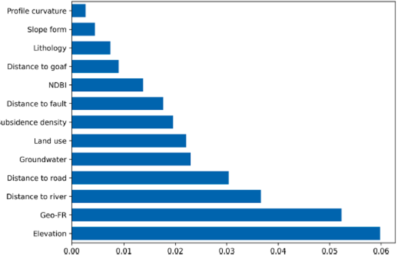
Figure 1. Importance ranking of landslide-related factors
These findings indicate that subsurface conditions resulting from mining activities deserve consideration in slope susceptibility analysis. In other words, mine landslide mitigation requires more comprehensive information than topographic and rainfall data alone.
The prediction model, which combined three methods frequency ratio, GeoDetector, and support vector machine achieved higher accuracy than the individual models. The combined model reached an accuracy of 0.91 on the test data, while the comparison models ranged from 0.85 to 0.88.
The resulting susceptibility map showed that most of the mining area fell into the low-risk category. However, high- and very-high-risk zones were concentrated along roads and valleys, some of which also overlapped with active subsidence zones.
Four mines Tunlan, Xiqu, Zhenchengdi, and Baijiazhuang recorded the largest proportions of high- and very-high-risk areas compared with other mines in the study area, at approximately 4.6%, 3.9%, 3.6%, and 3.2% of their respective areas.
READ ALSO: Guide to Measuring Mining Risks and Slope Protection
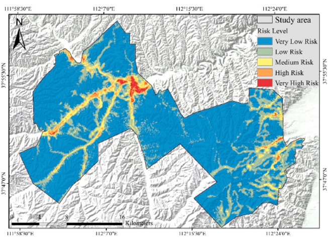
Figure 2. Landslide risk map
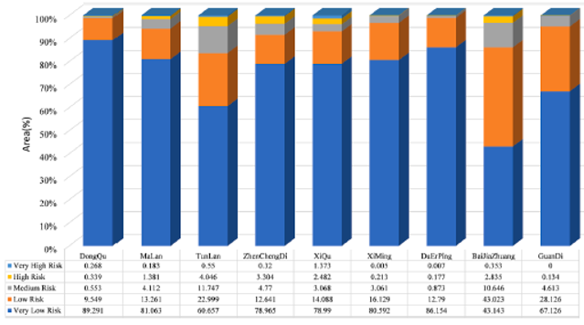
Figure 3. Statistics of at-risk areas in the mining region
What Does This Mean for Mine Landslide Mitigation?
The most direct implication of these findings is the need to change how slope monitoring is approached in mining areas.
If subsidence caused by underground mining can contribute to surface slope susceptibility, then maps of abandoned mining areas and subsidence density should be included in landslide monitoring databases. These data need to be considered alongside rainfall, slope angle, geological conditions, and other parameters.
Monitoring that relies only on rainfall sensors and surface movement measurements may provide an incomplete picture when the source of change lies beneath the surface.
In the context of mine landslide mitigation, mining history, abandoned mine boundaries, subsidence patterns, and changes in surface deformation can be used to identify areas that require greater attention.
This approach also helps establish treatment priorities. Not all mining areas have the same level of risk. Zones with extensive subsidence histories and located near roads, mining facilities, settlements, or critical infrastructure should be prioritized over areas with similar conditions but farther from human activities.
Mining History Determines Slope Treatment Strategies
Assessing slope stability in mining areas cannot stop at surface observations. The history of underground mining, distribution of abandoned mining areas, geological conditions, and subsidence patterns need to be considered from the investigation and preliminary assessment stages.
This information can help determine whether an area requires additional monitoring, a more detailed slope stability analysis, or remedial measures to improve soil and rock stability.
At the treatment stage, geotechnical engineering can form part of a mine landslide mitigation strategy, including the application of ground support, slope stabilization, and soil improvement in accordance with the geological conditions and failure mechanisms identified in the field.
Thus, mitigation should not begin only when cracks or slope movement become visible. It should start with an understanding of the history of mining activities and changes in subsurface conditions.
For mining areas with a history of underground mining, understanding what happens beneath the surface is just as important as observing what is visible above it. This approach provides the basis for designing more appropriate geotechnical solutions for mine landslide mitigation, whether through monitoring, stabilization, ground support, or soil improvement.
References
Dong, L., Zhang, J., Zhang, Y., & Zhang, B. (2024). Landslide risk assessment in mining areas using hybrid machine learning methods under fuzzy environment. Ecological Indicators, 167, 112736. https://doi.org/10.1016/j.ecolind.2024.112736 https://doi.org/10.1016/j.ecolind.2024.112736
- Share