

Mine Slope Failure Mitigation: Understanding Slope-Control Factors
When a mine slope fails, heavy rainfall is often considered the primary cause. While this assumption is not entirely incorrect, it does not fully explain why two slopes exposed to the same amount of rainfall can respond very differently. One slope may remain stable, while another gradually deforms and eventually fails.
This difference is the focus of the study by Wang et al. (2026), which combined satellite-based deformation monitoring with analyses of geological conditions and mining activities to better understand the mechanisms controlling slope instability.
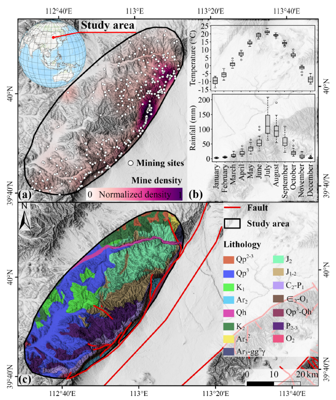

During the observation period, the number of slopes experiencing deformation increased during the rainy season. Both the median and maximum deformation values were also higher than those recorded during the dry season. However, these findings do not indicate that rainfall is the sole cause of slope failure.
When deformation data were analyzed alongside geological characteristics and mining operational conditions, it became evident that slope instability develops through the interaction of multiple factors acting simultaneously (Wang et al., 2026).
Slope Angle Is Not the Most Influential Factor
Slope angle is often the primary parameter considered when evaluating slope stability. The common assumption is straightforward: the steeper the slope, the greater the risk of failure. However, the findings of this study reveal a much more complex reality.
Using Random Forest and SHAP analyses, mine density emerged as the most influential factor affecting slope instability. Its contribution ranged from 0.059 to 0.082, exceeding that of proximity to faults (0.045–0.064) and slope angle, which contributed only 0.023–0.035 (Wang et al., 2026).
These results demonstrate that slope geometry cannot be evaluated independently of its surrounding environment. Mining activities, geological conditions, and subsurface structures may exert a greater influence on slope stability than the slope angle itself. Consequently, two slopes with nearly identical inclinations may exhibit significantly different levels of failure risk.
The relationship is also non-linear. The highest deformation risk was identified in areas with a mine density of approximately 0.1–0.2 and located about 1.5–2 km from active mining areas.
This finding indicates that slope instability develops as a response to the combined effects of mining operations and geological characteristics rather than any single controlling variable (Wang et al., 2026).
Small Changes Often Appear First
A slope does not collapse immediately once its equilibrium begins to deteriorate. In many cases, instability is preceded by subtle deformation that is too small to be detected through routine visual inspections.
Using SBAS-InSAR observations, the researchers identified several zones undergoing continuous ground movement before conducting field verification. On-site investigations subsequently revealed subsidence fissures up to approximately 1 meter wide, tension cracks reaching about 1.8 meters in width, and shallow slope blocks that had already experienced displacement (Wang et al., 2026).
These cracks were not the beginning of the problem but rather evidence of an instability process that had already been developing. Therefore, deformation monitoring becomes significantly more valuable when integrated with geological information, slope conditions, and mining activity data. Instead of merely recording ground movement, the data help explain why a particular slope begins to lose stability.
Slope stability is the result of interactions among multiple controlling factors. Rainfall, geological structures, lithology, and mining activities collectively influence how each slope responds to changing conditions.
The study by Wang et al. (2026) demonstrates that understanding the relationships among these factors provides a stronger basis for identifying high-risk areas than relying on a single parameter alone.
For the mining industry, this approach creates opportunities to target monitoring and mitigation efforts more effectively. APTEKINDO supports these efforts through geotechnical and ground support solutions designed based on a comprehensive understanding of slope behavior, enabling risks to be managed before they develop into slope failures. Learn more about APTEKINDO's ground support solutions by visiting aptekindo.com
References
Wang, P., Deng, H., Li, J., Jiang, Z., Tian, G., Liu, Y., & Pan, Z. (2026). Unraveling the controls of unstable slopes in mining-affected coalfields through InSAR observations and multivariate modeling. International Journal of Applied Earth Observation and Geoinformation, 146, 105089.
- Share