

Why Geotechnical Consulting Is the Starting Point for Successful Mining Projects
A project may have a well-developed design, a realistic construction schedule, and a carefully planned budget. However, all of these plans ultimately depend on one fundamental factor: whether the subsurface conditions have been properly understood. Many design changes that occur during construction are not the result of calculation errors, but rather because the actual characteristics of the soil or rock differ from the initial assumptions. This is precisely why geotechnical consulting has become an essential component of every stage of project planning.
In the mining industry, this challenge becomes even more significant. The construction of haul roads, supporting facilities, waste disposal areas, and mine openings all requires decisions based on the local geological and geotechnical conditions. Without sufficient information, projects face increased risks of ground settlement, slope instability, and construction method changes that can significantly affect both project costs and schedules.
Understanding the Site Before Choosing the Solution
Geotechnical consulting begins with a comprehensive understanding of the project site. This process, known as site characterization, involves collecting and integrating information about geological conditions, soil and rock properties, and the influence of groundwater within the proposed development area. According to Sjöberg et al. (2023), effective site characterization combines geological mapping, exploratory drilling, field testing, laboratory testing, and geophysical surveys to develop a more accurate understanding of subsurface conditions.
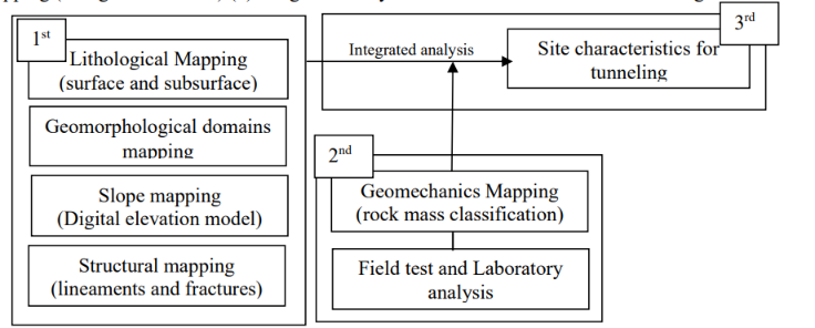
Methodological for Site Characterization
Each investigation method provides a different perspective. Borehole drilling reveals the sequence of soil and rock layers, laboratory testing determines the mechanical properties of the materials, while geophysical surveys help identify subsurface variations across larger areas. Together, these data are integrated into a geotechnical model that serves as the foundation for engineering decision-making.
It is important to recognize that the objective of geotechnical consulting is not simply to collect as much data as possible. Its real value lies in transforming that information into practical recommendations that support project objectives. Two sites may produce similar investigation results yet require entirely different engineering solutions because their structural functions, operational conditions, and risk profiles are rarely identical.
Transforming Data into Engineering Decisions
Investigation data only become valuable when they answer the specific needs of a project. Borehole logs, Standard Penetration Test (SPT) values, and laboratory parameters do not automatically produce design decisions. Instead, all available information must be analyzed collectively to understand how the soil or rock will behave under loading and how it may respond to changes caused by construction activities.
For example, the presence of a soft soil layer at a particular depth does not automatically require a different foundation system. Engineers must still evaluate the thickness of the layer, its lateral extent, groundwater conditions, and the loads imposed by the proposed structure. This analytical process distinguishes geotechnical consulting from simple site investigation. The emphasis is not on the quantity of data collected but on the quality and relevance of the engineering recommendations produced.
Within mining projects, interpretation becomes even more critical because field conditions evolve as mining operations progress. Slope geometries change with excavation, disposal areas continue to expand, and drainage systems can alter groundwater conditions. Decisions made during the initial planning stage must therefore be re-evaluated whenever new information indicates changes in site conditions. This adaptive approach ensures that engineering designs remain aligned with actual field conditions rather than relying solely on assumptions made during the early planning stages.
Uncertainty Cannot Be Eliminated, But It Can Be Managed
Soil and rock are natural materials formed through geological processes over millions of years. Their characteristics can vary considerably over relatively short distances, making it impossible to know every subsurface condition with complete certainty. Consequently, every engineering project involves some degree of uncertainty.
Einstein (1996) explains that the objective of Geotechnical Risk Assessment is not to eliminate risk entirely, but rather to identify potential problems during the planning stage so that appropriate mitigation measures can be developed before construction begins. This process starts by identifying potential hazards, evaluating the likelihood of their occurrence, estimating their potential consequences, and selecting the most appropriate risk control strategies.
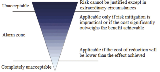
ALARP risk grading diagram
One of the most widely adopted concepts in geotechnical risk management is ALARP (As Low As Reasonably Practicable), which aims to reduce risks to a level that is technically and economically acceptable. This principle helps project teams compare alternative engineering solutions before construction starts. In many situations, modifying the design during the planning phase is significantly more efficient than implementing corrective measures after construction or mining operations have already commenced.
A risk-based approach also encourages the preparation of a risk register, a document that records potential project risks along with their corresponding mitigation strategies. Through this process, engineering decisions consider not only technical requirements but also their implications for safety, project costs, and construction schedules.
Sound Decisions Always Begin with Accurate Understanding
Every technical decision made during the early stages of a project influences all subsequent phases of construction. When subsurface conditions are well understood, designs can be developed with greater confidence, construction methods can be selected more appropriately, and potential risks can be identified before they become costly problems in the field.
For the mining industry, this approach is especially important because geological and geotechnical conditions continue to evolve throughout the life of a mine. Evaluating field data does not end when the initial investigation is completed; instead, it becomes an ongoing process throughout the entire project lifecycle. As a result, engineering decisions can be continuously updated to reflect actual site conditions rather than relying exclusively on assumptions made during project planning.
This philosophy underpins many modern geotechnical engineering applications, from foundation design and slope stability evaluation to determining the need for ground improvement, grouting, shotcrete, and injection systems for areas requiring reinforcement. Although these solutions differ technically, they all pursue the same objective: ensuring that engineering designs are fully compatible with actual site conditions.
As a company specializing in geotechnical solutions and mining construction, APTEKINDO views geotechnical consulting as the process of building a reliable foundation for informed engineering decisions. Field investigations, technical analyses, and risk assessments are integrated into a single workflow, enabling each solution to be tailored to the unique conditions and technical requirements of every project.
The success of a project is often measured by its final outcome. Yet behind that success lies a series of engineering decisions made long before construction begins. When those decisions are based on accurate data and comprehensive technical analysis, the likelihood of delivering a safe, efficient, and sustainable project increases significantly.
References
Einstein, H. H. (1996). Geotechnical Risk Assessment for Construction of Underground Structures. International Journal of Rock Mechanics and Mining Sciences, 33(2), 163–178.
Sjöberg, J., Johansson, D., Nordlund, E., Saiang, D., et al. (2023). Review of Geotechnical Site Characterization and Investigation Methods in Mining Projects. Mining, 3(4), 650–679.
- Share